Over 800,000 vertical profiles of Temperature and Salinity have been collected since 2004 in the World Ocean by attaching tags on marine mammals, such as Southern elephant seals.
In this website, you will find information about the marine mammal tagging programs, and an access point to the publicly available databases.
Please let us know if you are using our data. You can contact us by mail to info@meop.net if you have any question.
The MEOP data portal
Content of the website
Data format
Hydrographic data obtained with instrumented elephant seals are provided in a netCDF format following recommandations of the Marine-mammals NetCDF formats and conventions'' Version 1.2 [PDF] which is derived from the Argo netCDF User's manual. The Argo netCDF format is a standard used to store Argo float data on Argo data servers, and thus it is well adapted to record hydrographic profile data. Because marine mammals behave very much like Argo floats from the point of view of data sampling, this format is particularly well adapted to the storage of marine mammal hydrographic data.
Matlab and Python tools are available publicly to read and manipulate files with the netCDF format. They are given as an example. Note also that this format can be easily read by the software Ocean Data View (using the Import/Argo formats/Float Profiles menu). More tools can be obtained on GitHub.
1. netCDF formats for hydrographic profiles:
The netCDF profile format: For a thorough scientific use of the data, or for oceanographic data centers, it is advised to use the sea mammal netCDF format as it serves as the reference. This format can be easily read in Ocean Data View using the Import/ARGO profiles/Float profiles menu, or using your favorite data processing software (e.g. Python, Matlab, IDL). Matlab and python tools are also available publicly to read and manipulate files in netCDF format.
File naming convention: A single file is available for each single CTD-SRDL dataset (i.e. one tag deployment on one animal). The file name uses the manufacturer naming convention (giving a deployment code, a tag identifier, and the year for SMRU data), with the suffix “_prof.nc”.
Global attributes: Global attributes of the netCDF files provide important metadata:
1. pi_name = name of the principal investigator
2. species = string of character for the species
3. platform_code = Unique identifier number for the tag dataset
4. wmo_platform_code = WMO number when available
5. smru_platform_code = SMRU name (used in the file name)
6. deployment_code = SMRU deployment code
7. distribution_statement = "Follow MEOP data policy standards, cf. http://www.meop.net/the-dataset/data-access.html. Data available free of charge. User assumes all risk for use of data. User must display citation in any publication or product using data. User must contact PI prior to any commercial use of data"
8. citation = "The marine mammal data were collected and made freely available by the International MEOP Consortium and the national programs that contribute to it (http://www.meop.net)" ;
9. positioning_system = {“argos”,“gps”}
10. number_of_ts_profiles = ...
11. number_of_t_profiles = ...
Variables: The data file contains the raw and adjusted pressure, temperature, and salinity data with their associated quality flags. Adjustment equations are also stored with the corresponding coefficients. Here is a (non-exhaustive) list of the most relevant variables:
1. PI_NAME: Name of the principal investigator
2. STATION_PARAMETERS: List of available parameters
3. PLATFORM_NUMBER: Generic unique identifier (same as platform_code)
4. CYCLE_NUMBER: profile index, integer ranging from 1 (first dive) to N (last dive).
5. JULD_LOCATION: Julian day of the location relative to the 01/01/1950.
6. LATITUDE: Latitude of the station, best estimate
7. LONGITUDE: Longitude of the station, best estimate
8. PRES: Sea pressure in dbar
9. PRES_ADJUSTED: Adjusted sea pressure (in practice, pressure was not adjusted, so PRES=PRES_ADJUSTED)
10. PRES_ADJUSTED_QC: Quality flag (1 = good data).
11. TEMP: In-situ temperature (in degC)
12. TEMP_ADJUSTED: Adjusted in-situ temperature (in degC)
13. TEMP_INTERP: In-situ temperature interpolated on a regular vertical grid (in degC)
14. TEMP_ADJUSTED_QC: Quality flag (1 = good data).
15. TEMP_ADJUSTED_ERROR: Rough estimate of accuracy (single value per deployment).
16. PSAL: Practical salinity (in psu)
17. PSAL_ADJUSTED: Adjusted practical salinity (in psu)
18. PSAL_INTERP: Practical salinity interpolated on a regular vertical grid
19. PSAL_ADJUSTED_QC: Quality flag (1 = good data).
20. PSAL_ADJUSTED_ERROR: Rough estimate of uncertainty (single value per deployment)
21. SCIENTIFIC_CALIB_EQUATION: Calibration equations used to adjust data
22. SCIENTIFIC_CALIB_COEFFICIENT: Calibration coefficients
To facilitate the exploration of MEOP-CTD data, csv files have been created that list all the available profiles (list_profiles.csv), all available tags (list_tags.csv) and all available deployments (list_deployments.csv). The information listed in these tables is derived from the netCDF files and includes geolocation, platform names, dates, owner, etc.
2. Header list of all profiles, loggers and deployments
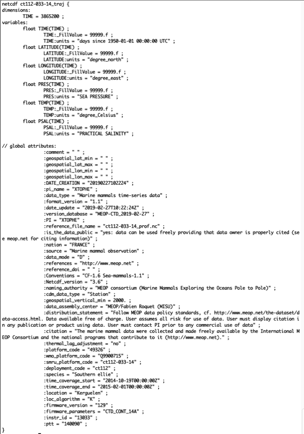
3. Binary netCDF formats for timeseries:
The netCDF traj format: This format is used to store and distribute trajectory ata obtained when data archiving loggers are retrieved. In this netCDF format, data are given as a function of time (given as Julian days since 01-01-1950) and hydrographic data are non-adjusted.