Over 800,000 vertical profiles of Temperature and Salinity have been collected since 2004 in the World Ocean by attaching tags on marine mammals, such as Southern elephant seals.
In this website, you will find information about the marine mammal tagging programs, and an access point to the publicly available databases.
Please let us know if you are using our data. You can contact us by mail to info@meop.net if you have any question.
The MEOP data portal
Content of the website
SMRU tags
The CTD-SRDL has been developed by the Sea Mammal Research Unit in St Andrews, Scotland, in collaboration with Valeport Ltd. For more details, see the technical page on the SEaOS website. A thorough description of CTD-SRDL tags can be found in Boehme et al. (2009). The CTD-SRDL is the only miniaturized tag with high-quality CTD capabilities to date, so it is the only type of tag included in the MEOP-CTD database at this stage. However, other CTD-capable tags might become available in a near future and they will happily be included in the MEOP-CTD database if their owner agree to it.
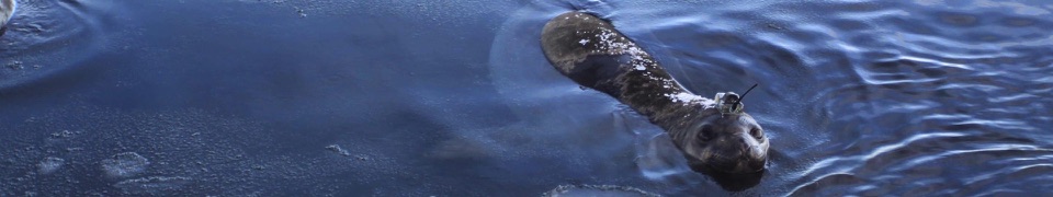
The Conductivity-Temperature Depth Satellite Relay Data Logger (CTD-SRDLs) is an autonomous tags that can be attached on marine animals. It consists of a miniaturized CTD which can sample vertical profiles of temperature and conductivity (from which salinity and density of seawater are derived), an Argos transmitter (PTT), a wet-dry sensor, a D-cell battery, a microprocessor. In later versions, a bluetooth transmitter and a flash memory have been included. It is also possible to include a fluorometer, an oxygen sensor or a Fastloc GPS. See the paper by Photopoulou et al. (2015) for more details.

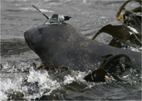
A CTD-SRDL tag, featuring a miniaturized CTD on top of the core unit, with the microcontroller below, the wet/dry sensor on the frontside, the battery on the rear, and the Argos antenna pointing
The CTD-SRDL is attached to the animal on land. Then it records hydrographic profiles during the ascent phase of animal dives, retaining only the deepest dive in each six-hour time interval, and transmitting profiles in a compressed form (between 10 and 25 data points per profile, depending on the tag programming) through the ARGOS system. Data are then extracted, formatted and stored at the Sea Mammal Research Unit (SMRU), and transmitted in real-time to the Global Telecommunication System (GTS).
First guess locations are determined based on the Doppler shifts observed from uplinks by CLS ARGOS. End-of-dive locations are then estimated using a straightforward least-squares method, or a more elaborated Kalman filtering method. The latter method has been developed recently, so it is used for the most recent CTD-SRDLs only. A simple speed filter is then applied to exclude locations that would require an unfeasibly high speed to reach its four neighbouring points (two before and two after), and a linear interpolation is finally applied between the locations that passed the filter. The accuracy of ARGOS geo-positioning is typically about ±5 km.
The CTD sensor head consists of a pressure transducer, a platinum resistance thermometer, and an inductive cell for measuring conductivity. The temperature and conductivity sensors have a precision (repeatability) of 0.005 °C and 0.005 mS/cm, respectively. Before being taken into the field, devices are calibrated in the laboratory by Valeport. Whenever possible, the CTD-SRDLs are also tested at sea against a ship-based CTD before the deployment.